# Known Limitations
SLYR will always follow the developments in ESRI and QGIS to provide conversion opportunities as new functionality is added to these applications. However, there are limitations in both QGIS and ESRI software which can prevent perfect results when converting documents between these applications.
This page lists limitations which we know can affect the quality of conversions made by SLYR, along with any workarounds you can use to help avoid conversion issues.
If you encounter a limitation that isn't listed, please email us and we will investigate it.
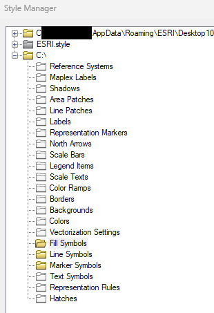
# Content in Source files
SLYR will process and utilize any available content. If no content is present, SLYR will have nothing to convert.
Workaround
To check if the content exists, open up the source file in its native software and check to see if the content is there.
- In this example, content exists only in the yellow folders. No content is illustrated as a white folder.
# Graduated renderer
SLYR cannot translate a QGIS "graduated renderer" to any comparable result in ArcGIS Pro when there are gaps between class ranges. ArcGIS Pro does not support gaps within class breaks.
Workaround
Adjust the graduated class breaks from the QGIS project to remove any gaps between the class ranges. If values should remain hidden, try creating classes for these hidden ranges and using a fully transparent symbol for them.
# Legend Text
It is not possible to automatically wrap legend text in current QGIS versions. When converting ESRI documents which use this option, SLYR will raise warnings but the resulting legend arrangement in the QGIS project will often be messy and need manual adjustment.
Workaround
Avoid using automatically wrapped text in ArcMap or ArcGIS Pro legends
# Converting QGIS projects to MXD/LYR
SLYR does not support converting QGIS projects into the older ArcMap MXD or LYR formats. However, it does support the conversion of QGIS projects to ArcGIS Pro formats like LYRX, MAPX, and APRX. Since ArcMap is now officially ceased development by ESRI, SLYR has concentrated its QGIS to ESRI conversion efforts on the newer, supported ArcGIS Pro formats.
Consequently, SLYR does not support exports of QGIS to MXD (or LYR), and we will not be adding this functionality in any future SLYR release.
Workaround
Export to the newer ArcGIS Pro formats instead
# Publishing to web services
SLYR offers several options for converting ESRI documents for use as web services. Depending on the target server, the process and limitations vary:
# QGIS Server
Using SLYR with QGIS Server offers close to a 1:1 match for the original ESRI rendering of layers. Just convert the ESRI projects to equivalent QGIS projects using one of the following tools, then publish the result to your QGIS server:
- Convert MXD/MXT to QGS
- Convert APRX to QGS
# MapServer
Basic ESRI symbology converts well. For more complex symbology, manual adjustments may be required.
Convert the ESRI projects to SLD (Styled Layer Descriptor) files, using one of the following SLYR tools:
- Convert LYR to SLD
- Convert LYRX to SLD
- Convert MXD to SLD
# GeoServer
Basic ESRI symbology converts well. For more complex symbology, manual adjustments may be required.
Convert the ESRI projects to SLD (Styled Layer Descriptor) files, using one of the following SLYR tools:
- Convert LYR to SLD
- Convert LYRX to SLD
- Convert MXD to SLD
As GeoServer does not support embedded (inline) SVG content, you will need to manually copy any SVG files generated during the conversion to a path accessible by your server. Make sure you specify a "Destination folder for SVG files" when running to SLD conversion tools, and populate the "Server path for SVG files" with the full server-accessible path where you will be copying these SVG files to.
# Raster Catalog Layers
Raster Catalog layers are a special feature in ArcMap. (The ArcGIS Pro equivalent is mosaic datasets.) In QGIS there is currently no equivalent to Raster Catalog or Mosaic Dataset layers. Accordingly, SLYR cannot convert these layers and these layer types will be skipped over when opening ArcMap or ArcGIS Pro documents.
Workaround
This functionality will become available only when QGIS itself supports raster catalog layers or mosaic datasets. If you're interested in funding this development within QGIS, please contact us.
# Rule-based renderers
One of our favorite features of QGIS Symbology is the ability to create efficient cartography through the use of "Rule-Based" renderers. This is an extremely powerful functionality, with no direct equivalent in current ArcGIS Pro versions. Therefore, if your QGIS project has many layers based on rule-based renderers, you may have issues when exporting to ArcGIS Pro formats.
SLYR will always attempt to convert rule based layers whenever it is possible to replicate the same results in ArcGIS Pro, but if this is not possible then a warning will be raised during the export and the QGIS layer styling will need to be adjusted accordingly.
Workaround
One potential workaround is to manually add a new field to the layer's attribute table which contains the name of each of rule which should be used to render that feature, and then convert the rule-based renderer to an equivalent categorized renderer using this new field.
- In QGIS, open up a layer's
attribute table. - Create the number of fields required to record each rule-based classification against the features.
- Select the fields according to your filter used in the rule-based classification.
- Populate the fields with the name of your rule-based classification.
- Save your edits.
- Change the layer to use a Categorized Renderer with symbology matching each of the original rule-based renderer rules.
# SLD - converting LYR/LYRX to SLD
These tools rely on QGIS' SLD export capabilities, and the quality of the conversion will depend on the symbology options used in the ArcMap documents and how compatible they are with QGIS' SLD support.
The SLD format itself has considerably less symbology functionality compared with either QGIS or ArcMap, therefore a conversion to SLD will often be a lossy process, dropping complex options back to simpler SLD supported symbology.
Workaround
Carefully check the resulting SLD symbology and compare against the original ArcMap or ArcGIS Pro symbology. Where differences are present, try simplifying the original ArcMap/ArcGIS Pro symbology to use simpler styling choices.
# Symbology - Units
Current ArcGIS Pro versions do not support map unit based symbol sizes. If your QGIS symbology is using sizes with the "map units" or "meters at scale" types, you'll need to change the type to something compatible with ArcGIS Pro's capabilities.
Workaround
Modify your QGIS symbols to use a fixed-unit size instead (eg Millimeters)
# Urgent fixes
If you have a large project impacted by limitations that requires an urgent fix, contact us and we can assist! In some cases we can:
- Undertake the conversion for you. This may attract a small fee, dependent on the work, but please ask.
- Missing functionality in QGIS can be sponsored so that we can directly add support for it.
By asking us, you are letting us know of the limitation and by delivering a solution for you, it may help develop a solution for all users of these tools and all QGIS users!