# Troubleshooting
# Cannot download SLYR from link
If you cannot download SLYR from the link provided, first try a different browser, including Chrome and Firefox. If this does not work, please contact us.
If you find you get the 401 Unauthorized page this may indicate that your organization has blocked access. Therefore, you will need to contact us for further installation requirements.
Please contact us at info@north-road.com and we will respond as soon as we can (with the caveat that we are in AEST time zone).
# You are asked for user credentials
If you are asked for your Username and Password when updating your plugin:
- Try re-running the installation routine from the welcome email (it's safe to re-run this over an existing SLYR install)
- Try installing SLYR using a new QGIS User Profile (opens new window)
If this does not fix the problem, please contact us at info@north-road.com and we will help you to reinstall.
# Warnings during conversions
During document conversion SLYR will raise warnings describing any properties from the document which cannot be automatically converted. The table below describes some of these warnings, and how they can be handled:
| Warning | Rectification or Explanation |
|---|---|
| Group transparency was converted to individual layer transparency (group transparency requires QGIS 3.24 or later) | Update your QGIS to QGIS 3.24 or later |
| Raster layers in Geodatabase files are not supported in QGIS | Update to a newer QGIS version for raster GeoDatabase support. |
| Raster catalog layer has been removed from the project (raster catalog layers are not supported by QGIS) | These layers will need to be created separately outside of the catalog layer before conversions. |
| Could not automatically convert expression. Please check and repair this expression. | A label or filter expression from the ESRI document could not be automatically converted to a QGIS expression. The layer will need to be modified and the expression manually converted to a QGIS equivalent by the user. |
| Unique Value legend group title is not supported by QGIS | This is a warning that the group title has been dropped in the QGIS layer. Legend text may need to be manually updated accordingly. |
| Font XXX not available on system | See fonts |
| Class Break legend group title is not supported by QGIS | This is a warning that the group title has been dropped in the QGIS layer. Legend text may need to be manually updated accordingly. |
| X: Marker halos are not supported by QGIS | The option used in the MXD isn't possible to match in current QGIS versions. In this case a warning is raised and the rest of the layer's properties are converted. |
| Mosaic layer has been removed from the project (Mosaic layers are not supported by QGIS) | This relates to a Mosaic layer in the MXD document -- current QGIS versions don't have any way of opening these so we skip over them during the conversion. |
| Vector marker symbol TextString | This feature is not yet available in SLYR, but we hope to include it in further updates. |
# Annotations and Annotation Classes
Annotations serve many different use cases in ESRI software. Depending on what type of annotation or annotation class you are converting and what your requirements are, SLYR offers a number of tools to meet your needs.
If you are converting:
- Text annotations stored in a File GeoDatabase annotation class, and want the result to be reusable across different projects, you should use the "Convert Annotation Classes to Geopackage" tool
- Text annotations stored in a File GeoDatabase annotation class, and just want the results added to the current project, you should use the "Convert Annotations" tool
- Graphical or text annotations which are stored in an ArcGIS Project file (eg a MXD, LYR, APRX, LYRX file) and the underlying data source is NOT a File GeoDatabase annotation class, then use the corresponding tool for converting this document type should be used. (E.g. Convert MXD to QGS).
# Authenticated connections
When converting an ESRI project which contains private ESRI online services, WMS/WFS services, or database connections SLYR cannot automatically convert the credentials required for accessing these services, and the resulting QGIS project will contain broken layers.
However, if you create authenticated connections in QGIS to these services before converting the ESRI projects, SLYR will automatically match the connections and copy the credentials stored within QGIS. This avoids the need for any manual layer repair.
- Create a stored connection to the service or database from the QGIS Data Source Manager. (For ESRI online services you can follow the instructions from our blog post (opens new window) to handle the authentication setup).
- For ESRI services make sure that your QGIS stored connection is pointing at the "top most" level of the REST server, by removing any specific endpoints from the end of the URL i.e. instead of
https://services.arcgis.com/abcxyz/arcgis/rest/services/Class_breaks/FeatureServer/0>, usehttps://services.arcgis.com/abcxyz/arcgis/rest/services/.- Then convert the ArcMap/ArcGIS Pro documents.
The conversion should be successful, with an advisory message informing that the stored credentials have been used.
# Fonts
When converting ArcMap or ArcGIS Pro documents, you will need to have all
fonts referenced by the documents installed on your system. If any fonts are
not available, SLYR will display warnings listing all missing fonts.
For best conversion results you should source these missing fonts and install them on the system.
Unfortunately, due to licensing restrictions, we are unable to distribute any of the ESRI fonts along with SLYR. Users will need to source these fonts from a workstation with ArcMap or ArcGIS Pro installed and install them manually onto their workstations.
# GeoDatabases
# Missing or invisible features
If some features do not display from GeoDatabase layers, there may be an error with the Geodatabase Layer's Index.
Workaround:
- In ArcGIS Pro, open the GDB file in the
Catalog.- Under the
Indexestab, choose whether to rebuild the index, remove or re-create it.- Rerun the SLYR tool.
# Personal GeoDatabases (MDB/PGDB)
If you are running Windows, you may come across some issues with the conversion of Personal GeoDatabases (PGDB). Some manual configuration is needed before these can be opened within QGIS. You may need administrative rights on your computer in order to complete these steps.
Fix:
- Download and install the 64-bit version of the ODBC driver from Microsoft (opens new window)
If you don't have a 32-bit version of office installed you can just run the executable. If, however, you do have a 32-bit office installation you will need to run the executable from a command prompt using the "/passive" argument.
# Raster GeoDatabase Layers
Support for raster layers from GeoDatabases was recently introduced in QGIS. Please ensure that you have QGIS v3.30.3 or v3.28.7 (or later) to enable this support.
# Raster Catalog Layers
These are not supported in any QGIS version, and will be omitted from any converted documents.
# Export Data to Geodatabase
QGIS has inbuilt support for many more files than are supported in ArcGIS Pro. When exporting a QGIS project for use in ArcGIS Pro, you may first need to convert some layer data sources to an ESRI readable format. We suggest exporting the data to File GeoDatabases for best compatibility with ESRI software. You can either export data to a new GeoDatabase, or to an existing GeoDatabase (go from step 3 below).
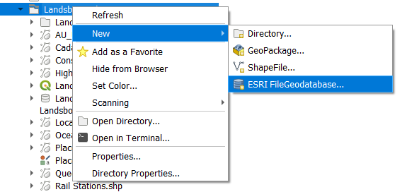
- In the QGIS Browser window, right-mouse click the folder you wish to create
the geodatabase in and click on
New▶️ESRI FileGeodatabase. - Type in the name of the geodatabase
- Find and select the layers you wish to export to the GeoDatabase.
- Drag and drop the selected layers onto the new GeoDatabase.
- Repath the layers in your QGIS project to point to the exported GeoDatabase
layers (right-mouse click the layer and click on
Change Data Source).
# LYR files
# Repairing Data Sources
When you convert ESRI documents using SLYR and
the Repair data source icon appears next to the data, this means the path to the data is broken and
will need to be manually repaired.
icon appears next to the data, this means the path to the data is broken and
will need to be manually repaired.
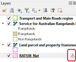
There's a number of possible causes for this, but ultimately it means that QGIS can't find the data files referenced by the ESRI file. For instance:
- The data has been moved.
- The data no longer exists.
- The ESRI file has relative paths to the data files (eg .\transport\roads.shp), yet the converted QGIS file wasn't saved to the same location as the original ESRI file. We recommend always placing the converted QGIS files into the same folder alongside their original ESRI counterparts for best results.
Workaround:
Click the
Repair data source
# Nested Joins
A nested joins is when table A is joined to table B which is itself joined to table C. These are currently not supported by SLYR.
# Symbology
The following are some issues you may encounter during conversions of symbols.
# Marker Symbols
Marker halos are not supported in QGIS, as there's no way in current QGIS versions to achieve the same effect. During conversion SLYR will ignore the marker halo setting, and you may need to adjust your symbology accordingly.
# Reporting Bugs
If a tool is not working, we apologize that this is impacting your workflow! If it is a bug, we will rectify as soon as possible.
How to report bugs:
- If you are using the fully licensed SLYR, email us immediately with as much as detail as possible including the files. We will look into the bug and get back to you with a solution. Once solved, we will push up a new version to the QGIS Plugin Manager with all the fixes.
- Check if you are using the Community Edition or the Licensed Edition of SLYR. If you are using the Community Edition, then the tool is likely not yet available in the license version. Please note that we don't offer any direct support for the Community Edition.
# Updating SLYR
We are constantly improving SLYR, and releasing new updates to the tool on a frequent basis. We recommend that you regularly update the SLYR plugin in order to use the latest version, or you will miss out on all the new features and fixes we implement!
# How to update the SLYR plugin
- From QGIS, open the QGIS Plugin Manager (opens new window)
- Navigate to the "Plugins" menu > "Manage and Install Plugins".
- In the Plugin Manager window, go to the "Installed" tab.
- If an update to SLYR is available, it will be marked with an update icon (⬆️).
- Click the "Upgrade All" button (if multiple plugin updates are available) or select SLYR and click "Upgrade".
After installing a SLYR update, you can read everything which has changed by looking at the "Changelog" section in the QGIS Plugin Manager window. Alternatively, changelogs are available to read online.
← FAQ Known Limitations →